Identification of Burned Areas Using Spectral Indexes and Sentinel 2 Images in Mayarí, Holguin
Article Sidebar
Main Article Content
Abstract
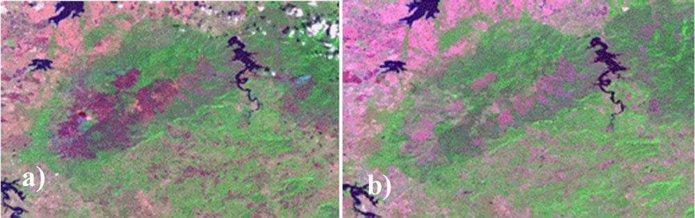
This research aims to identify burned areas within the municipality of Mayarí in the Mensura-Piloto National Park from Sentinel 2 satellite images, obtained free of charge through the Browser Copernicus Data Space portal. Annually during the dry season this municipality is affected by fire, caused mainly by anthropogenic and tropical action. Sometimes this phenomenon gets out of control, causing large fires that seriously affect the ecosystem of the region. The NBR spectral index is used to highlight the areas affected by fires and to classify the severity of the event, showing as a result a classification according to a range of key values in qualitative continuous order offered by the Key & Benson severity thresholds (100 / 270 / 440 / 660 / Max). The ranger sites reported a total of 3 612 ha of Burned Area, classified between burn zones with high, moderate and low severity, which corresponds to 2,77% of the total area of the municipality, a worrying figure, which should alert the municipal government officials in charge of Disaster Risk Management, to assess damages and analyze the respective recovery processes of vegetation cover and the ecosystem in an effective manner.
Article Details

This work is licensed under a Creative Commons Attribution-NonCommercial 4.0 International License.
Aquellos autores/as que tengan publicaciones con esta revista, aceptan los términos siguientes:
- Los autores/as conservarán sus derechos de autor y garantizarán a la revista el derecho de primera publicación de su obra, el cuál estará simultáneamente sujeto a la Licencia de reconocimiento-no comercial de Creative Commons 4.0 que permite a terceros compartir la obra siempre que se indique su autor y su primera publicación esta revista. Bajo esta licencia el autor será libre de:
- Compartir — copiar y redistribuir el material en cualquier medio o formato
- Adaptar — remezclar, transformar y crear a partir del material
- El licenciador no puede revocar estas libertades mientras cumpla con los términos de la licencia
Bajo las siguientes condiciones:
- Reconocimiento — Debe reconocer adecuadamente la autoría, proporcionar un enlace a la licencia e indicar si se han realizado cambios. Puede hacerlo de cualquier manera razonable, pero no de una manera que sugiera que tiene el apoyo del licenciador o lo recibe por el uso que hace.
- NoComercial — No puede utilizar el material para una finalidad comercial.
- No hay restricciones adicionales — No puede aplicar términos legales o medidas tecnológicas que legalmente restrinjan realizar aquello que la licencia permite.
- Los autores/as podrán adoptar otros acuerdos de licencia no exclusiva de distribución de la versión de la obra publicada (p. ej.: depositarla en un archivo telemático institucional o publicarla en un volumen monográfico) siempre que se indique la publicación inicial en esta revista.
- Se permite y recomienda a los autores/as difundir su obra a través de Internet (p. ej.: en archivos telemáticos institucionales o en su página web) antes y durante el proceso de envío, lo cual puede producir intercambios interesantes y aumentar las citas de la obra publicada. (Véase El efecto del acceso abierto).
References
Ariza, A. (2012). Tecnologías satelitales para mapeo de susceptibilidad a incendios forestales. https://www.un-spider.org/sites/default/files/2_Suceptibilidad_a_Incendios_AA_ONU-SPIDER_2020.pdf
Centro de Gestión de la Biosfera (CGB). (2023). Cuba en datos: Incendios forestales-Clima y acción humana. https://www.mtss.gob.cu/noticias/cuba-en-datos-incendios-forestales-clima-y-accion-humana
Chuvieco, E., Cifuentes, Y., Hantson, S., López, A. A., Ramo, R., & Torres, J. (2012). Comparación entre focos de calor MODIS y perímetros de área quemada en incendios mediterráneos. Revista de Teledetección, 37, 9-22.
Copernicus. (2025). Browser dataspace. https://browser.dataspace.copernicus.eu
De Santis, A., & Chuvieco, E. (2009). GeoCBI: A modified version of the Composite Burn Index for the initial assessment of the short-term burn severity from remotely sensed data. Remote sensing of Environment, 113(3), 554-562.
Delegido, J., Pezzola, A., Casella, A., Winschel, C., Urrego, P., Jimenez-Munoz, J.-C., Sobrino, J., Soria, G., & Moreno, J. (2018). Estimación del grado de severidad de incendios en el sur de la provincia de Buenos Aires, Argentina, usando Sentinel-2 y su comparación con Landsat-8. Revista de Teledetección, 51, 47-60,
Di Bella, C. M., Posse, G., Beget, M. E., Fischer, M. D. L. A., Mari, N., & Verón, S. (2008). La teledetección como herramienta para la prevención, seguimiento y evaluación de incendios e inundaciones. Ecosistemas, 17(3), I
ECURED-Cuba. (2025). Parque Nacional La Mensura. Enciclopedia Cubana Digital. https://www.ecured.cu/Parque_Nacional_La_Mensura
Fernández-Manso, A., Fernández-Manso, O., & Quintano, C. (2016). SENTINEL-2A red-edge spectral indices suitability for discriminating burn severity. International journal of applied earth observation and geoinformation, 50, 170-175.
Fornacca, D., Ren, G., & Xiao, W. (2018). Evaluating the best spectral indices for the detection of burn scars at several post-fire dates in a mountainous region of Northwest Yunnan, China. Remote Sensing, 10(8), 1196.
Heredia, Á., Martínez, S., Quintero, E., Piñeros, W., & Chuvieco, E. (2003). Comparación de distintas técnicas de análisis digital para la cartografía de áreas quemadas con imágenes LANDSAT ETM+. GeoFocus. International Review of Geographical Information Science and Technology, 3, 216-234.
Huertas, A., Baptiste, B. L. G., Toro, M., & Huertas, H. (2019). Manejo de la quema de pastizales de sabana inundable: Una mirada del pueblo originario Sáliva en Colombia. Chungará (Arica), 51(1), 167-176.
Keeley, J. E. (2009). Fire intensity, fire severity and burn severity: A brief review and suggested usage. International journal of wildland fire, 18(1), 116-126.
Key, C. H., & Benson, N. C. (2006). Landscape assessment (LA). In: Lutes, Duncan C.; Keane, Robert E.; Caratti, John F.; Key, Carl H.; Benson, Nathan C.; Sutherland, Steve; Gangi, Larry J. 2006. FIREMON: Fire effects monitoring and inventory system. Gen. Tech. Rep. RMRS-GTR-164-CD. Fort Collins, CO: US Department of Agriculture, Forest Service, Rocky Mountain Research Station. p. LA-1-55, 164.
Metallanes, R. (2019). Lo que debes saber sobre imágenes Sentinel-2. GIS and Beers. http://www.gisandbeers.com/lo-deberias-saber-imagenes-sentinel-2/
Miller, S. D., Straka III, W., Mills, S. P., Elvidge, C. D., Lee, T. F., Solbrig, J., Walther, A., Heidinger, A. K., & Weiss, S. C. (2013). Illuminating the capabilities of the suomi national polar-orbiting partnership (NPP) visible infrared imaging radiometer suite (VIIRS) day/night band. Remote Sensing, 5(12), 6717-6766, ISSN: 2072-4292.
Parra, A. del C., Bernal, F. H., Armenteras, D., González, F., Morales, M., Pabón, D. J., & Páramo, G. E. (2011). Incendios de la cobertura vegetal en Colombia.
QGIS. (2025). QGIS official website. https://qgis.org
Satellites Onfire. (2025). Satellites on fire-Historical hotspots. https://app.satellitesonfire.com/focos-historicos
Sebastian, B., González, T. M., & Armenteras, D. (2017). Dinámica espacio temporal de ocurrencia de incendios en zonas con diferentes tipos de manejo en el noroeste de la amazonia: ¿barrera efectiva? Revista facultad de ciencias básicas, 13(1), 19-25.
Tecnitop S.A. (2025). Cartografía de incendios forestales con QGIS 3.6. https://tecnitop.com/cartografia-de-incendios-forestales-con-qgis-3-6/
World Wildlife Fund (WWF). (2016). WWF Colombia. https://www.wwf.org.co