Validación de índices espectrales de humedad mediante imágenes del Landsat 8 OLI/TIRS en un Vertisol
Barra lateral del artículo
Contenido principal del artículo
Resumen
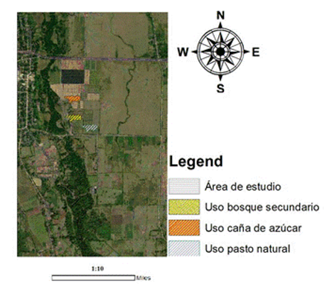
La teledetección es una herramienta geomática que ha sido utilizada para determinar la humedad del suelo, propiedad física muy importante en estudios relacionados con la producción agropecuaria. Particularmente, los Vertisoles presentan características distintivas a otros agrupamientos de suelos en Cuba con relación a la retención de agua y el cambio de sus propiedades. El objetivo de la investigación se basó en validar el uso de índices espectrales de humedad mediante imágenes del Landsat 8 OLI/TIRS en un Vertisol. Se escogió un área bajo pasto natural, caña de azúcar y bosque secundario de la Estación Provincial de Investigaciones de la Caña de Azúcar en Guaro, Holguín. Se establecieron tres puntos de muestreo aleatorios georreferenciados por cada uso de la tierra hasta una profundidad de 30,0 cm, para la determinación de la humedad gravimétrica la cual, se relacionó mediante análisis de regresión lineal con los índices espectrales de humedad y el cálculo de parámetros para su validación. El uso de la teledetección mostró en los mapas temáticos obtenidos de la estimación de la humedad con los diferentes índices espectrales la presencia de zonas homogéneas y su variabilidad espacial en el estado de humedad del Vertisol bajo los tres usos de la tierra. Los índices ENDWI, MSI y EMSI indicaron una mejor estimación en los estadígrafos utilizados para la validación de los valores obtenidos por teledetección y muestreos in situ de la humedad, de acuerdo a investigaciones relacionadas con la temática.
Detalles del artículo

Esta obra está bajo una licencia internacional Creative Commons Atribución-NoComercial 4.0.
Aquellos autores/as que tengan publicaciones con esta revista, aceptan los términos siguientes:
- Los autores/as conservarán sus derechos de autor y garantizarán a la revista el derecho de primera publicación de su obra, el cuál estará simultáneamente sujeto a la Licencia Creative Commons Attribution-NonCommercial 4.0 International (CC BY-NC 4.0) que permite a terceros compartir la obra siempre que se indique su autor y su primera publicación esta revista. Bajo esta licencia el autor será libre de:
- Compartir — copiar y redistribuir el material en cualquier medio o formato
- Adaptar — remezclar, transformar y crear a partir del material
- El licenciador no puede revocar estas libertades mientras cumpla con los términos de la licencia
Bajo las siguientes condiciones:
- Reconocimiento — Debe reconocer adecuadamente la autoría, proporcionar un enlace a la licencia e indicar si se han realizado cambios. Puede hacerlo de cualquier manera razonable, pero no de una manera que sugiera que tiene el apoyo del licenciador o lo recibe por el uso que hace.
- NoComercial — No puede utilizar el material para una finalidad comercial.
- No hay restricciones adicionales — No puede aplicar términos legales o medidas tecnológicas que legalmente restrinjan realizar aquello que la licencia permite.
- Los autores/as podrán adoptar otros acuerdos de licencia no exclusiva de distribución de la versión de la obra publicada (p. ej.: depositarla en un archivo telemático institucional o publicarla en un volumen monográfico) siempre que se indique la publicación inicial en esta revista.
- Se permite y recomienda a los autores/as difundir su obra a través de Internet (p. ej.: en archivos telemáticos institucionales o en su página web) antes y durante el proceso de envío, lo cual puede producir intercambios interesantes y aumentar las citas de la obra publicada. (Véase El efecto del acceso abierto).
Citas
ALEXAKIS, D.D.; MEXIS, F.D.K.; VOZINAKI, A.E.K.; DALIAKOPOULOS, I.N.; TSANIS, I.K.: “Soil moisture content estimation based on Sentinel-1 and auxiliary earth observation products. A hydrological approach”, Sensors, 17(6): 1-16, 2017, ISSN: 1424-8220, Publisher: MDPI, DOI: https://doi.org/10.3390/s17061455.
AMANI, M.; PARSIAN, S.; MIRMAZLOUMI, S.M.; AIENEH, O.: “Two new soil moisture indices based on the NIR-red triangle space of Landsat-8 data”, International Journal of Applied Earth Observation and Geoinformation, 50: 176-186, 2016, ISSN: 0303-2434, Publisher: Elsevier, DOI: http://dx.doi.org/10.1016/j.jag.2016.03.018.
BAO, Y.; LIN, L.; WU, S.; DENG, K.A.K.; PETROPOULOS, G.P.: “Surface soil moisture retrievals over partially vegetated areas from the synergy of Sentinel-1 and Landsat 8 data using a modified water-cloud model”, International journal of applied earth observation and geoinformation, 72: 76-85, 2018, ISSN: 1569-8432, Publisher: Elsevier, DOI: https://doi.org/10.1016/j.jag.2018.05.026.
CHAMPAGNE, C.; ROWLANDSON, T.; BERG, A.; BURNS, T.; L’HEUREUX, J.; TETLOCK, E.; ADAMS, J.R.; AHMADI, H.; TOTH, B.; ITENFISU, D.: “Satellite surface soil moisture from SMOS and Aquarius: Assessment for applications in agricultural landscapes”, International journal of applied earth observation and geoinformation, 45: 143-154, 2016, ISSN: 1569-8432, Publisher: Elsevier, DOI: https://doi.org/10.1016/j.jag.2015.09.004.
CHEN, D.; HUANG, J.; JACKSON, T.J.: “Vegetation water content estimation for corn and soybeans using spectral indices derived from MODIS near-and short-wave infrared bands”, Remote Sensing of Environment, 98(2-3): 225-236, 2005, ISSN: 0034-4257, Publisher: Elsevier.
CID, L.G.; HERRERA, P.J.; LÓPEZ, S.T.; GONZÁLEZ, R.F.: “Resultados de algunas investigaciones en suelos Vérticos de Cuba”, Revista Ingeniería Agrícola, 6(2): 51-56, 2016, ISSN: 2227-8761.
CUMBRERA-GONZÁLEZ, R.A.; ROMAGOSA, W.; MILLÁN, H.; SORIA, A.; GASKIN, B.: “Estimación de la dependencia espacial del contenido de humedad de un vertisol”, Revista Ingeniería Agrícola, 5(2): 16-22, 2015, ISSN: 2227-8761.
DOMÍNGUEZ, J.; KUMHÁLOVÁ, J.; NOVÁK, P.: “Assessment of the relationship between spectral indices from satellite remote sensing and winter oilseed rape yield”, Agron. Res, 15(1): 55-68, 2017.
HERNÁNDEZ, J.A.: “Área que ocupan los agrupamientos y tipos genéticos de los suelos en Cuba”, Cultivos tropicales, 42(3), 2021, ISSN: 0258-5936, Publisher: Ediciones INCA.
HERNÁNDEZ, J.A.; PÉREZ, J.J.M.; MESA, N.A.; BOSCH, I.D.; RIVERO, L.; CAMACHO, E.: Nueva versión de la clasificación genética de los suelos de Cuba., Ed. AGRINFOR, La Habana, Cuba, ISBN: 959-246-022-1, Barcaz L L ed., vol. I, La Habana, Cuba, 93 p., 2015, ISBN: 959-246-022-1.
HERNÁNDEZ-PEREIRA, Y.; MEDINA-GONZÁLEZ, H.: “Estimación de la humedad del suelo mediante técnicas de asimilación de datos”, Revista Ciencias Técnicas Agropecuarias, 21(4): 30-35, 2012, ISSN: 2071-0054, Publisher: Universidad Agraria de La Habana.
HWAN, S.; HEON, D.; HOON, J.: “A new measure for assessing the efficiency of hydrological data-driven forecasting models”, Hydrological Sciences Journal, 57(7): 1257-1274, 2012, DOI: https://doi.org/10.1080/02626667.2012.710335.
JALILVAND, E.; TAJRISHY, M.; HASHEMI, S.A.; BROCCA, L.: “Quantification of irrigation water using remote sensing of soil moisture in a semi-arid region”, Remote Sensing of Environment, 231: 111226, 2019, ISSN: 0034-4257, Publisher: Elsevier.
MOHAMMADI, A.; COSTELLOE, J.F.; RYU, D.: “Application of time series of remotely sensed normalized difference water, vegetation and moisture indices in characterizing flood dynamics of large-scale arid zone floodplains”, Remote sensing of environment, 190: 70-82, 2017, ISSN: 0034-4257, Publisher: Elsevier, DOI: http://dx.doi.org/10.1016/j.rse.2016.12.003.
QIU, J.; CROW, W.T.; WAGNER, W.; ZHAO, T.: “Effect of vegetation index choice on soil moisture retrievals via the synergistic use of synthetic aperture radar and optical remote sensing”, International Journal of Applied Earth Observation and Geoinformation, 80: 47-57, 2019, ISSN: 1569-8432, Publisher: Elsevier, DOI: https://doi.org/10.1016/j.jag.2019.03.015. 14. QIU, JIANXIU.; CROW, WADE.; W.
SILVA, R.F.; ALBUQUERQUE, J.A.; DA COSTA, A.; FONTOURA, S.M.; BAYER, C.; WARMLING, M.I.C.: “Physical properties of a Hapludox after three decades under different soil management systems”, Revista Brasileira de Ciência do Solo, 40: 1-14, 2016, ISSN: 1806-9657, Publisher: SciELO Brasil, DOI: https://doi.org/10.1590/18069657rbcs20140331.
SINGH, K.; KUMAR, S.; KUMAR, R.: “Synergetic methodology for estimation of soil moisture over agricultural area using Landsat-8 and Sentinel-1 satellite data”, Remote Sensing Applications: Society and Environment, 15: 1-8, 2019, ISSN: 2352-9385, Publisher: Elsevier, DOI: http://dx.doi.org/10.1016/j.rsase.2019.100250.
WILSON, M.; CERANA, J.: “Mediciones físicas en suelos con características vérticas”, Revista Científica Agropecuaria, 8(1): 11-22, 2004, ISSN: 0329-3602.
ZHAN, Z.; QIN, Q.; GHULAN, A.; WANG, D.: “NIR-red spectral space based new method for soil moisture monitoring”, Science in China Series D: Earth Sciences, 50(2): 283-289, 2007, ISSN: 1006-9313, Publisher: Springer, DOI: https://doi.org/10.1007/s11430-007-2004-6.
ZHANG, J.; ZHOU, Z.; YAO, F.; YANG, L.; HAO, C.: “Validating the modified perpendicular drought index in the North China region using in situ soil moisture measurement”, IEEE Geoscience and Remote Sensing Letters, 12(3): 542-546, 2014, ISSN: 1545-598X, Publisher: IEEE, DOI: http://dx.doi.org/10.1109/LGRS.2014.2349957.