INTRODUCTION
Sustainable development will be defined by the availability and quality of water, if one considers that it is a vital element for the existence of all living beings and there is not yet another element or substance that replaces it (Troballes, 2015).
The quantity and quality of water are parameters that make up the environmental system for the calculation of the environmental sustainability index, which considers the ability of countries to safeguard the environment in the future (García, 2017). The World Organization of the United Nations to define sustainable development identifies these indicators. Hence the importance of its study in watersheds.
Water quality is not a fixed parameter, but is subject to spatial-temporal variation. On the other hand, depending on the type of use, the thresholds of the variables are determined. The requirements for human consumption are much more demanding than in the case of use for agricultural production and livestock (ICB Editores, 2017). This research is based on the state of the art for the quality of surface water used in agricultural irrigation.
The water quality from surface sources is affected by several factors, mainly anthropic. Such is the case of specific polluting sources like industries and settlements that discharge their wastewater into rivers and streams, as well as outbreaks of diffuse pollution, for example, high-input agriculture whose effluents reach the water courses through surface and underground runoff (Firdaus et al., 2014).
At the same time, that agriculture needs irrigation. Therefore, it is necessary to know the quality of the water that is applied in irrigation to avoid soil degradation, crop damages and their possible incidence in human health (Porta et al. 2014).
Faced with this situation, there is a need to quantify and evaluate the quality of water bodies, which refers to their composition and the extent to which it is affected by the concentration of substances produced by natural and anthropic processes (Severiche & Barreto, 2013). Quality in its strictest sense is defined by three fundamental criteria: salinity, sodicity and toxicity (Pizarro, 1985).
Water quality is evaluated starting from the laboratory analysis where fundamental and derived physical, chemical and biological properties are determined. Example of the first are: temperature, pH, electrical conductivity, content of anions and cations, heavy metals, total and fecal coliforms, among others. The derived variables can be diverse, among them are: Effective Salinity, Potential Salinity, Sodium Adsorption Ratio, Possible Sodium Percent, Dissolved Sodium Percent and Langelier Index (Balmaseda & García, 2013).
In Ecuadorian coastal region, there are areas where water courses are contaminated by mining activity, agrotoxins used in agriculture for the control of pests (insects, diseases and weeds), remains of population settlements and of industries, among other possible causes (González, 2015).
Rainfall in Babahoyo area, Los Ríos Province, Ecuador, exceeds 2000 mm in most of the years recorded. The problem lies in the fact that the temporary distribution of these rains has the same tendency in the country, according to records of 24 years taken by the Meteorological Station located at the Technical University of Babahoyo. The monthly average from January to April is 456.8 mm, while from May to December the average is 43.8 mm. Hence the importance of irrigation in agricultural crops during the dry period (Bonilla et al., 2013; Bonilla, 2015; Caicedo et al., 2015, 2017; Guerrero, 2015; Rodríguez & Silva, 2015).
To satisfy water needs of the crops in Babahoyo region, a source of fundamental supply is San Pablo River, however, there are no previous studies that demonstrate its quality. For this reason, the objective of this work is to evaluate the quality of the waters of this river course and in this way determine its aptitude for agricultural irrigation.
METHODS
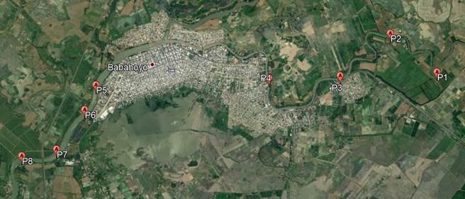
The study area is located between the geographical coordinates 1 ° 48'15.2 "S 79 ° 28'12.8" W and 1 ° 49'23.5 "S 79 ° 33'49.5" W of the datum PSAD 56, in Babahoyo City, of Los Ríos Province, Ecuador. Sampling was carried out in water intakes for irrigation, located upstream and downstream of Babahoyo City as it is shown in Table 1 and Figure 1. The volume taken from each source was 2.5 liters, to facilitate the analysis, according to the Analytical Techniques Manual elaborated by Paneque et al. (2005).
TABLE 1.
Sampling points on San Pablo River

FIGURE 1.
Spatial location of the sampling points.
Sites 1 to 4, are located upstream of Babahoyo City, while from 5 to 8, are located downstream of that location.
Sampling was done in the mentioned sites, both in humid and dry seasons, on March 03 and November 10, 2017, respectively. These dates constituted significant moments in the year due to the volumes of water available during the wet period (large avenues) and because it is the maximum dry season in the dry period.
The pH determinations were made with a direct reading potentiometer, electrometric method; the electrical conductivity was determined with a conductivity meter at 25º C, the results are expressed in dS.m-1, electrometric method.
The determinations of calcium, sodium, magnesium, potassium, chlorides, sulfates, carbonates and bicarbonates, were made according to standardized methods for physical-chemical analysis in the Laboratory of Soils, Vegetable Tissues and Waters of the Experimental Station of the South Coast of the Autonomous National Institute of Agricultural Research (INIAP).
To determine the suitability of water for irrigation, the following criteria were used:
FAO Guidelines for determining the quality of waters for agriculture (Ayers & Westcot, 1985).
Analysis of derived indicators related to irrigation:
Effective salinity (SE):
Potential Salinity (SP):
Adjusted Sodium Adsorption Ratio (RASx):
Percentage of sodium posible:
Percent of dissolved sodium:
Langelier Index:
Wilcox diagram: to determine the classification of waters according to their contents of total soluble salts and sodium.
RESULTS AND DISCUSSION
Below is an analysis of the water quality of San Pablo River for agricultural uses from three perspectives: (i) Contents of anions and cations; (ii) Derived indicators to evaluate water quality for irrigation; (iii) Classification of the waters according to the Wilcox diagram.
Analysis of Contents of Anions and Cations
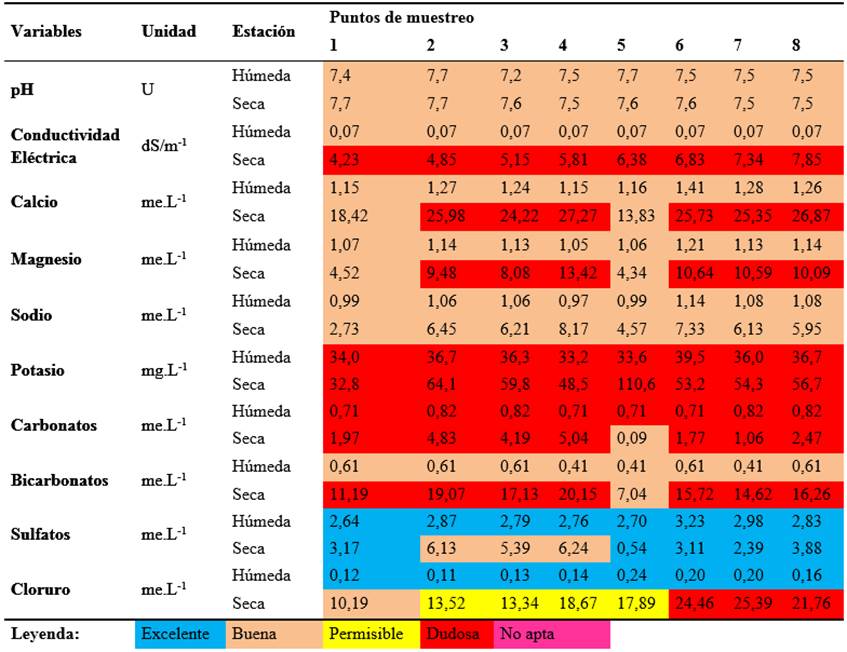
Table 2 shows the physical-chemical composition of the waters of the sampled sites in San Pablo River basin. The values of each variable were studied according to the guidelines to interpret the quality of waters for irrigation (Ayers & Westcot, 1985). A color legend has been prepared to express the quality of the water analyzed for agricultural uses.
In all samples, pH reached values within the range established for irrigation waters (6.0 - 8.5), independently of the sampling times.
Values of electrical conductivity (CE) are extremely low during the wet season; they remain almost invariable in the area studied. However, samples taken in the dry season have EC values above 4 dS / m-1, which increase downstream from the city of Babahoyo. In all cases, its degree of restriction for agricultural use is severe, given that in the first four points the conductivity is very high, while in the rest it is considered excessive (Duarte & Díaz, 2005).
In the wet season, in which irrigation is not necessary, all the ions studied have low values, this is supposed to happen because the salts are dissolved in the large volumes of water that circulate in the river. While in the dry season the flow of the river decreases bringing with it the increase in the concentration of anions and cations (Table 2).
Calcium content at sampling site 1 is within the permissible range for irrigation water (<20 me.L-1). In points 2, 3 and 4, the Ca + 2 exceeds the allowable threshold, then descends to 11.72 me.L-1 and again increases to values greater than 26 me.L-1. In Figure 1, it can be seen that between sampling points 4 and 5, the flow of Catarama River is added, which contributes an important flow, so it is assumed that the decrease in calcium content is due to the fact that salts dissolve in that stretch of the river. It is presumed that between points 5 and 6 the channel receives contributions of residuals from the city that cause the increase of all the elements, as can be seen in Table 2.
It should be noted that magnesium (threshold <5 me.L-1) and bicarbonates (limit <20 me.L-1) have a behavior similar to that described for calcium, in terms of restrictions on use for agricultural irrigation.
TABLE 2.
Physical-chemical composition in the eight water intakes for agricultural use
The contents of sodium and sulfates are admissible according to FAO Guidelines on water quality (Duarte & Díaz , 2005). Chlorine is one of the elements considered toxic for the irrigation of crops when it exceeds certain values. In Table 2, it can be seen that chlorides increase as the sampled waters progress through the city of Babahoyo. It is presumed that this is because the river current of San Pablo River receives wastewater from rice-pumping companies, from lubricators and car washers, and from the collection channel for the discharges of Babahoyo Irrigation and Drainage System, that receives the surplus from rice plantations in the area.
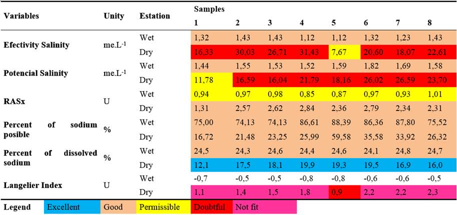
Analysis of Derived Indicators to Evaluate Water Quality for Irrigation
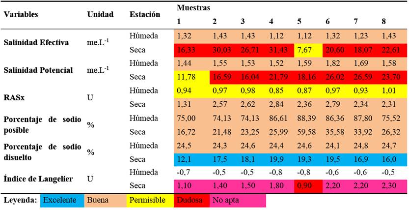
Table 3 shows the result of the calculation of the derived indicators, as expected in the wet season; all are suitable for the irrigation of agricultural crops, except the adjusted sodium adsorption ratio that when combined with the low values of electrical conductivity makes it a water of permissible quality.
In the dry season, the effective and potential salinities have high values, which lead to classify these waters as doubtful for use in irrigation of agricultural crops.
The indicators related to sodium contents (Percent of possible sodium and Percent of dissolved sodium) are classified as good or excellent. Logically, that is given because sodium contents in those waters are low.
When analyzing Langelier Index, it is evident that the use of these waters, in the dry season, can bring with it a very high risk of obstruction of the emitters of the irrigation systems. If they are classified according to the criteria of Fuentes & García (1999), which state that values higher than 1.00 are very high so that the water would practically not be suitable for localized irrigation systems or sprinklers with small nozzle diameters. In the wet season the opposite effect occurs, that is, the values of the Langelier Index are negative, which means that in this case the waters are corrosive, being their use, a risk in metal pipes.
TABLE 3.
Indicators of suitability of waters for use in agricultural irrigation
Classification of Waters According to the Wilcox Diagram
With the use of EASY_QUIM V5.0 program proposed by Vásquez (2012), the sampling points were interpolated in the Wilcox diagram with the purpose of classifying the analyzed waters. As it can be seen in Figure 2, all samples taken in the dry season are classified as C4S1, that is, very high salinity, generally not suitable for use in agriculture. If it is necessary to use it, it must be in very permeable soils, of good drainage, overdoses must be applied to wash the salts of the soil and in crops that are very tolerant to salinity.
As for sodium, its contents are low (S1), so the waters are suitable for watering almost all crops, except those that are very sensitive to this element.
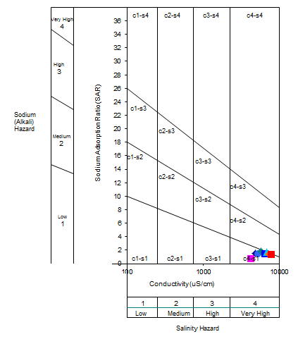
FIGURE 2.
Classification of waters for irrigation of San Pablo River basin according to the Wilcox diagram.
CONCLUSIONS
The high rainfall of the wet season causes large flows in San Pablo River and dissolves the salts, so in this period the water is of good quality, although it is practically not necessary to irrigate the crops.
In the dry season the flow of the San Pablo River decreases considerably, bringing with it an increase in the contents of the dissolved salts, until the waters are of dubious quality or not suitable for the irrigation of agricultural crops.